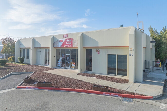
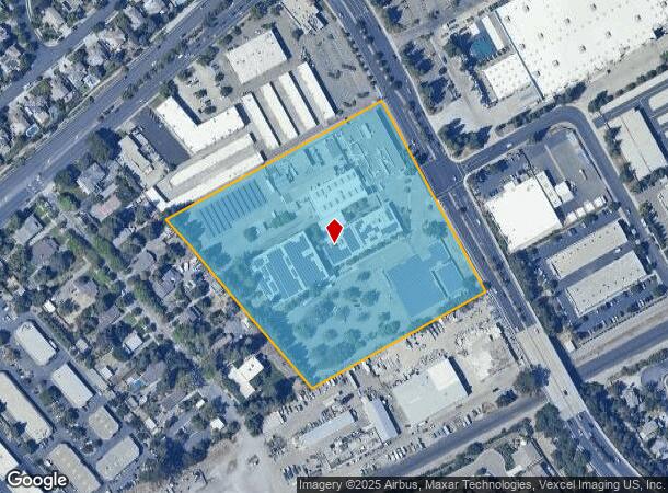
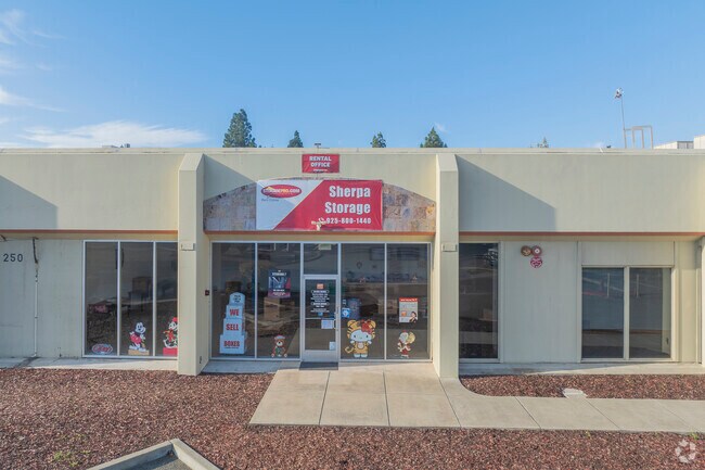
Property Record
250 N Mines Rd, Livermore, CA 94551

NEARBY LISTINGS FOR SALE OR LEASE
Property Detail
250 N Mines Rd
99-40-14-33
Parcel Map 1019
Lightindustrial
LOT: 0000E BLK: PM: 0079 PAGE: 0058 ;LOT: 0000F BLK: PM: 0079 PAGE: 0058
X
Alameda
06001C0353G
California
2024
8.94 AC
2025
Livermore
451503
East Bay/Oakland
109,631 SF
Oakland-Hayward-Berkeley, CA
DEMOGRAPHICS near 250 N Mines Rd
1 Mile
3 Mile
5 Mile
2024 Total Population
12,278
70,998
85,665
2029 Population
11,880
68,594
82,719
Pop Growth 2024-2029
(3.24%)
(3.39%)
(3.44%)
Average Age
42
41
42
2024 Total Households
4,385
25,577
30,511
HH Growth 2024-2029
(3.47%)
(3.56%)
(3.62%)
Median Household Inc
$140,480
$134,708
$144,464
Avg Household Size
2.70
2.70
2.70
2024 Avg HH Vehicles
2.00
2.00
2.00
Median Home Value
$873,872
$874,421
$914,983
Median Year Built
1976
1978
1979
Nearby Places
Map Layers
Map Styles
 Street
 Aerial
- Restaurants
- Banks
- Shops
- Fitness
- Groceries
PUBLIC TRANSPORTATION
COMMUTER RAIL
DRIVE
WALK
Distance
5 min
1.7 mi
Vasco (Altamont Corridor Express - Altamont Commuter Express (ACE))
DRIVE
WALK
Distance
Vasco (Altamont Corridor Express - Altamont Commuter Express (ACE))
4 min
2.0 mi
AIRPORT
Metro Oakland International
DRIVE
WALK
Distance
Metro Oakland International
39 min
29.8 mi
Norman Y Mineta San Jose International
DRIVE
WALK
Distance
Norman Y Mineta San Jose International
46 min
33.1 mi
Stockton Metro
DRIVE
WALK
Distance
Stockton Metro
47 min
36.7 mi
Freight Ports
Port of Oakland
DRIVE
WALK
Distance
Port of Oakland
43 min
34.4 mi
Nearby Properties
Address
Land Use
TOTAL SIZE
Lot Size
Zoning
Address
Land Use
TOTAL SIZE
Lot Size
Zoning
609,984 SF
34.43 AC
Address
Land Use
TOTAL SIZE
Lot Size
Zoning
212,048 SF
4.04 AC
Address
Land Use
TOTAL SIZE
Lot Size
Zoning
372,574 SF
19.75 AC
Address
Land Use
TOTAL SIZE
Lot Size
Zoning
322,482 SF
15.52 AC
Address
Land Use
TOTAL SIZE
Lot Size
Zoning
183,774 SF
15.21 AC
Address
Land Use
TOTAL SIZE
Lot Size
Zoning
89,049 SF
8.17 AC
Address
Land Use
TOTAL SIZE
Lot Size
Zoning
178,938 SF
7 AC
Address
Land Use
TOTAL SIZE
Lot Size
Zoning
267,413 SF
14.02 AC
Address
Land Use
TOTAL SIZE
Lot Size
Zoning
241,591 SF
12.75 AC
Address
Land Use
TOTAL SIZE
Lot Size
Zoning
144,058 SF
11.52 AC
Address
Land Use
TOTAL SIZE
Lot Size
Zoning
94,332 SF
8.89 AC
Address
Land Use
TOTAL SIZE
Lot Size
Zoning
128,622 SF
6.68 AC
Address
Land Use
TOTAL SIZE
Lot Size
Zoning
75,564 SF
3.34 AC
Address
Land Use
TOTAL SIZE
Lot Size
Zoning
166,692 SF
8.24 AC
Address
Land Use
TOTAL SIZE
Lot Size
Zoning
150,063 SF
4.96 AC
Address
Land Use
TOTAL SIZE
Lot Size
Zoning
333,938 SF
19.21 AC
Address
Land Use
TOTAL SIZE
Lot Size
Zoning
88,789 SF
5.63 AC
Address
Land Use
TOTAL SIZE
Lot Size
Zoning
99,280 SF
6.11 AC
Address
Land Use
TOTAL SIZE
Lot Size
Zoning
75,236 SF
6.42 AC
Address
Land Use
TOTAL SIZE
Lot Size
Zoning
70,472 SF
7.13 AC
Address
Land Use
TOTAL SIZE
Lot Size
Zoning
135,039 SF
13.45 AC
Address
Land Use
TOTAL SIZE
Lot Size
Zoning
244,337 SF
8.27 AC
Address
Land Use
TOTAL SIZE
Lot Size
Zoning
111,172 SF
6.06 AC
Address
Land Use
TOTAL SIZE
Lot Size
Zoning
90,500 SF
4.94 AC
Address
Land Use
TOTAL SIZE
Lot Size
Zoning
157,610 SF
12.84 AC
Address
Land Use
TOTAL SIZE
Lot Size
Zoning
88,633 SF
9.54 AC
Address
Land Use
TOTAL SIZE
Lot Size
Zoning
276,065 SF
13.13 AC
Address
Land Use
TOTAL SIZE
Lot Size
Zoning
73,561 SF
5.81 AC
Address
Land Use
TOTAL SIZE
Lot Size
Zoning
51,178 SF
2.09 AC
CO
Address
Land Use
TOTAL SIZE
Lot Size
Zoning
119,184 SF
13.19 AC
The World's #1 Commercial Real Estate Marketplace
Connect with us
© 2026 CoStar Group
The information above has been obtained from sources believed reliable. While we do not doubt its accuracy we have not verified it and make no guarantee, warranty or representation about it. It is your responsibility to independently confirm its accuracy and completeness. Any projections, opinions, assumptions, or estimates used are for example only and do not represent the current or future performance of the property. The value of this transaction to you depends on tax and other factors which should be evaluated by your tax, financial, and legal advisors. You and your advisors should conduct a careful, independent investigation of the property to determine to your satisfaction the suitability of the property for your needs.